“Global Aerial Imaging Market to reach a market value of USD 8.73 Billion by 2031 growing at a CAGR of 15.7%”
The Global Aerial Imaging Market size is expected to reach $8.73 billion by 2031, rising at a market growth of 15.7% CAGR during the forecast period.
The Asia Pacific segment witnessed 36% revenue share in the market in 2023. This growth is fueled by rapid urbanization, robust industrial expansion, and a surge in technological adoption across countries like China, India, Japan, and Australia. These nations have heavily invested in advanced imaging technologies for applications in agriculture, urban planning, disaster management, and infrastructure development.
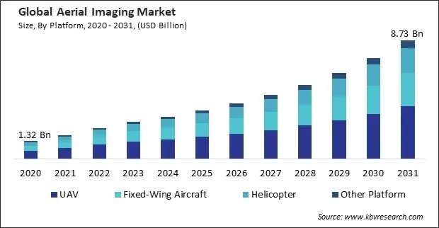
The demand for geospatial data has been rising steadily across various industries, driven by the need for accurate and real-time insights. Businesses, governments, and research institutions increasingly leverage these imaging to obtain precise geographic and spatial data for better decision-making. Aerial imagery is crucial in urban planning, infrastructure development, transportation management, and resource allocation, allowing organizations to analyze landscapes, detect changes, and monitor assets efficiently. Hence, as organizations continue to recognize the value of geospatial data, this market is expected to experience sustained growth.
Additionally, Infrastructure development, land use planning, and traffic management are all facilitated by the utilization of aerial imagery by governments and urban planners. In infrastructure development, these imaging offers unparalleled insights into current and potential future urban layouts. Cities like Singapore have harnessed aerial imagery to monitor the progress of large-scale infrastructure projects, ensuring that new developments are integrated seamlessly with existing structures. Thus, as technological advancements continue to enhance the capabilities of these imaging, its role in shaping the future of urban landscapes is only set to grow.
However, these imaging relies on specialized equipment such as drones, helicopters, fixed-wing aircraft, high-resolution cameras, LiDAR systems, and thermal sensors, all of which come at a premium cost. The investment required for purchasing and maintaining this equipment can be substantial, especially for organizations looking to scale their operations. Hence, the high initial costs associated with these imaging negatively impact the market growth.
Based on platform, the market is classified into UAV, fixed-wing aircraft, helicopter, and others. The fixed-wing aircraft segment procured 28% revenue share in the market in 2023. Fixed-wing aircraft are propelled by their ability to cover expansive areas with extended flight times and high efficiency. Their robust design and capacity to carry heavier payloads make them indispensable for large-scale mapping, environmental monitoring, and surveying applications.
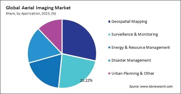
On the basis of application, the market is divided into geospatial mapping, surveillance & monitoring, energy & resource management, disaster management, urban planning, and others. The surveillance & monitoring segment recorded 23% revenue share in the market in 2023. Rising security concerns, increased crime rates, and the growing need for real-time situational awareness fuel the surveillance & monitoring segment. Law enforcement agencies, border security forces, and disaster response teams leverage aerial imaging for enhanced surveillance, patrolling, and crowd monitoring.
By end use, the market is segmented into government, agriculture & forestry, military & defense, energy, civil engineering, commercial, media & entertainment, and others. The military & defense segment acquired 13% revenue share in the market in 2023. The segment benefits from the rising demand for real-time intelligence, surveillance, and reconnaissance (ISR) operations. Defense agencies worldwide rely on these imaging to monitor borders, detect threats, and plan strategic military operations. The integration of high-resolution imaging, thermal sensors, and AI-driven analytics has significantly enhanced aerial surveillance capabilities.
Free Valuable Insights: Global Aerial Imaging Market size to reach USD 8.73 Billion by 2031
Region-wise, the market is analyzed across North America, Europe, Asia Pacific, and LAMEA. The North America segment garnered 31% revenue share in the market in 2023. This market in North America is driven by the well-established digital infrastructure, strong government initiatives, and high adoption of advanced technologies. The United States and Canada lead in aerial imaging applications across sectors such as military & defense, energy, and environmental monitoring.
| Report Attribute | Details |
|---|---|
| Market size value in 2023 | USD 2.78 Billion |
| Market size forecast in 2031 | USD 8.73 Billion |
| Base Year | 2023 |
| Historical Period | 2020 to 2022 |
| Forecast Period | 2024 to 2031 |
| Revenue Growth Rate | CAGR of 15.7% from 2024 to 2031 |
| Number of Pages | 260 |
| Number of Tables | 430 |
| Report coverage | Market Trends, Revenue Estimation and Forecast, Segmentation Analysis, Regional and Country Breakdown, Porter’s 5 Forces Analysis, Company Profiling, Companies Strategic Developments, SWOT Analysis, Winning Imperatives |
| Segments covered | Platform, Application, End Use, Region |
| Country scope |
|
| Companies Included | Google LLC (Alphabet Inc.), Esri, Inc., Hexagon AB, Trimble, Inc., DroneDeploy, Inc., Nearmap Ltd., EagleView Technology Corporation, Kucera International Inc., Cooper Aerial Surveys Co., and High Eye Aerial Imaging Inc. |
By Platform
By Application
By End Use
By Geography
This Market size is expected to reach $8.73 billion by 2031.
Increasing Demand For Geospatial Data are driving the Market in coming years, however, Substantially High Initial Costs restraints the growth of the Market.
Google LLC (Alphabet Inc.), Esri, Inc., Hexagon AB, Trimble, Inc., DroneDeploy, Inc., Nearmap Ltd., EagleView Technology Corporation, Kucera International Inc., Cooper Aerial Surveys Co., and High Eye Aerial Imaging Inc.
The expected CAGR of this Market is 15.7% from 2023 to 2031.
The Geospatial Mapping segment led the maximum revenue in the Market by Application in 2023, thereby, achieving a market value of $2.3 billion by 2031.
The Asia Pacific region dominated the Market by Region in 2023, and would continue to be a dominant market till 2031; thereby, achieving a market value of $3.2 billion by 2031.
Our team of dedicated experts can provide you with attractive expansion opportunities for your business.
 Drivers
 Restraints
 Opportunities
 Challenges
