The Latin America, Middle East and Africa Satellite Data Services Market would witness market growth of 19.1% CAGR during the forecast period (2024-2031).
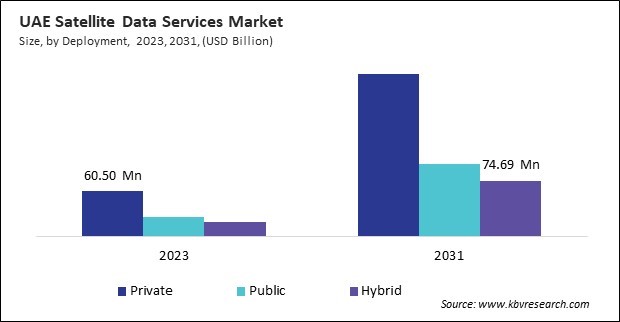
The Brazil market dominated the LAMEA Satellite Data Services Market by Country in 2023, and would continue to be a dominant market till 2031; thereby, achieving a market value of $784.6 million by 2031. The Argentina market is showcasing a CAGR of 20.7% during (2024 - 2031). Additionally, The UAE market would register a CAGR of 18% during (2024 - 2031).

Regulatory support and open data initiatives are driving the expansion of this market, making high-resolution satellite imagery more accessible for research and commercial applications. Space agencies like NASA, ESA, and ISRO have implemented open-data policies, allowing businesses, researchers, and governments to utilize satellite data for climate monitoring, disaster management, agriculture, and urban planning.
Alongside data accessibility, government funding and policy support are accelerating advancements in satellite technology. Policies promoting public-private partnerships, financial incentives, and space sustainability regulations encourage investments in low-Earth orbit (LEO) satellites, geospatial analytics, and AI-driven space applications.
Governments and private-sector players across the region increasingly leverage satellite-based communication, remote sensing, and earth observation to address economic, environmental, and security challenges. With rising investments in national space programs, geospatial intelligence, and AI-powered satellite analytics, LAMEA is emerging as an important player in the global industry. Brazil’s satellite data services market is primarily driven by agriculture, environmental conservation, and disaster resilience. As one of the world’s largest agricultural producers, Brazil relies on satellite imagery for precision farming, soil analysis, and climate adaptation strategies. South Africa is working on expanding its space-based communication networks, ensuring reliable geospatial intelligence for national security operations. With government initiatives promoting satellite-driven research, environmental monitoring, and commercial applications, South Africa is strengthening its position in the African space industry. Hence, as the demand for high-resolution satellite imagery, AI-powered analytics, and cloud-based geospatial intelligence continues to grow, the LAMEA region is expected to become a key player in this market.
Free Valuable Insights: The Worldwide Satellite Data Services Market is Projected to reach USD 37.78 Billion by 2031, at a CAGR of 16.6%
Based on End Use, the market is segmented into Commercial, Government & Military, and Service Providers. Based on Deployment, the market is segmented into Private, Public, and Hybrid. Based on Service, the market is segmented into Image Data Service and Data Analytics Service. Based on Application, the market is segmented into Environmental & Climate Monitoring, Defense & Security, Energy & Utilities, Agriculture & Forestry, Engineering & Infrastructure Development, Marine, and Other Application. Based on countries, the market is segmented into Brazil, Argentina, UAE, Saudi Arabia, South Africa, Nigeria, and Rest of LAMEA.
By End Use
By Deployment
By Service
By Application
By Country
Our team of dedicated experts can provide you with attractive expansion opportunities for your business.

